Thursday, 16 August 2018

TEARS AND GLACIERS –NEW ZEALAND JOURNEY

BLOG POST 30
We left Hokitika and proceeded to Franz Josef , en route we passed by  Ross which was 27.2 km from Hokitika ,it was made famous in 1909 when New Zealand’s largest  gold nugget was mined there weighing  an impressive 2.8 kgs.
Our drive from here was through inland, passing many beautiful lakes before finally arriving at Franz Josef ,though we tried to doze, the scenery outside wouldn’t let us do so .
We saw a rugged coastline with deserted beaches, dense rain forest and glaciers with backdrop of the Southern Alps .Many of the trees lining the coast were heavily bent and angulated which gave an indication of the powerful prevailing westerly weather patterns.
Lake Mahinapua  just 10km south of Hokitika is a scenic reserve offering a freshwater dip on a hot day or bird watching opportunities,
The road headed inland occasionally, giving us an insight into the lifestyle of the coasters with small hamlets and townships. Some had local carvers operating out their studios as well as a small museum of Maori artefacts.
We finally reached Franz Josef a small town, at the entrance of the valley, it has a permanent population of approximately 330 residents and is situated 5 km from the glacier on State Highway 6 ,has a petrol station, small but busy heliport, numerous tourist accommodation options (with up to 2,000 people staying overnight during the main season) and a number of restaurants, hotels and shops.
Just south of the village, a sealed road lead from highway into the Franz Josef Glacier valley and to a car park. Several small walks start from  Valley Road and  car park, and it was also possible to comfortably cycle from Franz Josef township to the car park.

The first European description of one of the west coast glaciers (believed to be Franz Josef) was made in the log of the ship Mary Louisa in 1859. The glacier was later named after Emperor Franz Joseph I of Austria by German explorer, Julius Von Haast in 1865.
The Māori name for the glacier is Kā Roimata o Hine Hukatere ('The tears of Hine Hukatere'), arising from a local legend . Hine Hukatere loved climbing in the mountains and persuaded her lover, Wawe, to climb with her. Wawe was a less experienced climber than Hine Hukatere but loved to accompany her until an  avalanche swept Wawe from the peaks to his death. Hine Hukatere was broken-hearted and apparently her profuse tears flowed down the mountain and froze to form the glacier .
Name of the glacier was later officially altered to Franz Josef Glacier  It is a 12 km  long  temperate maritime glacier located in Westland Tai Putini Park .
 Together with the Fox Glacier 20 km to the south, and a third glacier, it descends from the Southern Alps to less than 300 metres above sea level.
The Franz Josef Glacier is approximately 7000 years old .The ecosystem around the glacier is extremely unique due to the combination of the ice meeting the Waiho River and the surrounding rain forest.
 Franz Josef is the steepest and fastest moving glacier in New Zealand. The steep form of the glacier creates the perfect conditions for ice flow. One impressive Franz Josef glacier fact is that this glacier has been recorded as moving up to 4 metres per day. As compared to the average glacier moving at around 50cm to 1 metre per day
Fed by a 20-square-kilometre large snowfield  at high altitude, it exhibits a cyclic pattern of advance and retreat, driven by differences between the volume of melting water at the foot of the glacier and volume of snowfall feeding the neve.
 The glacier advanced rapidly during Little Ice age, reaching a maximum in the early eighteenth century. Having retreated several kilometres between 1940s and 1980s, the glacier entered an advancing phase in 1984
A postage stamp was issued in 1946, depicting the view from St James Anglican Church, built in 1931, with a panoramic altar window to take advantage of its location. By 1954, the glacier had disappeared from view from the church, but it reappeared in 1997. This is due to the highly variable conditions on the snowfield, which take around 5–6 years before they result in changes in the terminus location.
The glacier was still advancing until 2008, but since then it has entered a very rapid phase of retreat. As of 2018 it is again rapidly advancing. As is the case for most other New Zealand glaciers which are mainly found on the eastern side of the Southern Alps, the shrinking process is attributed to global warming
Based on past variations, scientists expect that Franz Josef Glacier will retreat 5 km and lose 38% of its mass by 2100 in a mid-range scenario of warming.
The area surrounding the two glaciers is part of Te Wahipounamu,  a World Heritage Site park. The river emerging from the glacier terminal of Franz Josef is known as the Waiho River.
There are several ways to explore the glacier from independent walks to heli-hikes ,we had some people from our tour who wanted to do the helicopter rides
The best is probably Sentinel Rock which is 10 minutes from the car park or the Ka Roimate o Hine Hukatere walk which is a more energetic 40 minute walk that leads to the terminal of the glacier
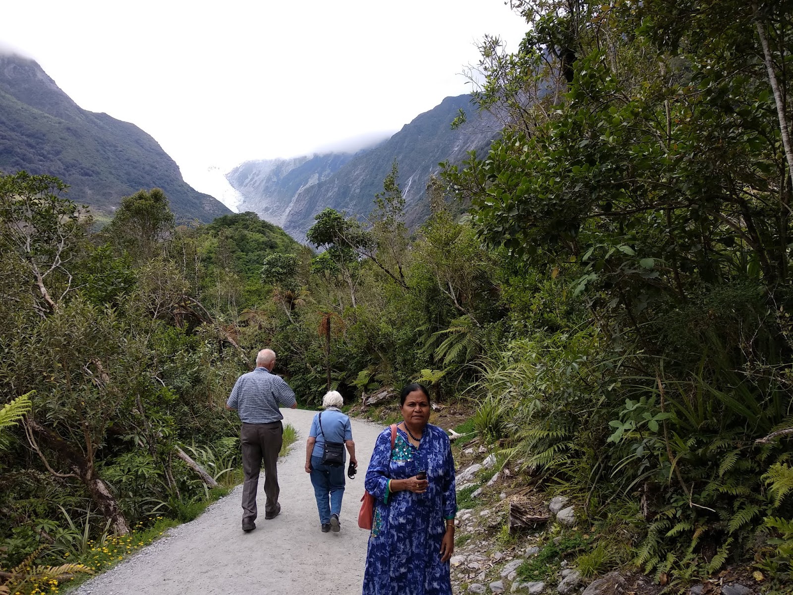
We and the others who opted out of the heli tour proceeded to the snout of the receding Franz Josef glacier after the heli riders got out at the information/visitor centre .
At the starting point there was a board giving daily updates on the distance to be walked to have a close glance at the glacier
As we started walking we could see the glacier tempting us to come nearer ,the path though rugged was manageable as seniors also could be seen walking with agility along the path.We could see the melted water flowing from the gracier
I remembered our Tony saying that once upon a time the glacier was visible even from the restaurant of the hotel we would be staying for that night
Viewing the glacier pure white and glistening in the sun was a true pleasure and I wished I had gone on the heli ride

We went as far as we could go near the glacier and returned to the bus which took us to the Scenic hotel where we met the heli riders who couldn’t go for the ride due to bad weather conditions
 A further 27km of twisty, winding road leads one into the smaller community of Fox with the terminal face of its glacier just five kilometres from the township.
Best way to experience the glacier is to walk on them. Small group walks with experience guides and equipment provided can be booked in the town of Franz and offer half or full day trips up onto the glacier
 For those with a few more dollars to spare, a heli-hike offers two fantastic opportunities; see the sheer scales of the glacier from the skies but also get onto the glacier much higher up where the ice is much purer, chance to discover blue-ice caves and pristine ice formations
 Home of New Zealand’s highest skydive at 19,000ft, Franz Josef is also one of the most scenic places in the world to skydive as we soar down over the spectacular glacier with Mount Cook in the backdrop
After the brisk walk and a nice dinner we slept soundly and met our other friends over the breakfast table ,there we were surprised to hear that there was a fire alarm in the early hours which finally turned out to be a false one
Other places to see in that town were west coast wild life centre containing kiwi birds and hot springs and Kayaking on Lake Mapourika

Friday, 3 August 2018

HOKITIKA -TOWN OF GREEN STONE-NEW ZEALAND JOURNEY

BLOG POST 29

We got down at Arthur’s pass and watched our train leave for its next destination .Arthur's Pass was previously called Camping Flat then Bealey Flats, it is a town in Southern Alps of South Island of New Zealand, located in the Selwyn district and is a popular base for exploring Arthur’s Pass National Park. The town and the pass are named after Sir Arthur Dudley Dobson (1841–1934). In 1929 the Arthur’s Pass National Park was created which is New Zealand's third National Park

Arthur's Pass town is about 5 km south of mountain pass with the same name. Its elevation is 740 metres above sea level and is surrounded by beech forest. The Bealey River runs through the township. 
There are several good walks from here, including the Devil's Punchbowl Falls, Bealey Valley and Avalanche Peak. 
The mischievous Kea (New Zealand mountain parrot) can be found here. About 48 cm long, it is mostly olive-green with a brilliant orange under its wings and has a large, narrow, curved, grey-brown upper beak.
 The kea is the world's only alpine parrot. Its omnivorous diet includes carrion, but consists mainly of roots, leaves, berries, nectar, and insects. 
The kea nest in groups in burrows or crevices among roots of trees and are known for their intelligence and curiosity, vital to their survival in a harsh mountain environment. They can solve logical puzzles, such as pushing and pulling things in orderly manner to get to food for example pushing the lid off a dust bin to get at the food inside, and they work together to achieve a certain objective.  
The kea's notorious urge to explore and manipulate makes this bird both a pest for residents and an attraction for tourists. Called "the clown of the mountains", it will investigate backpacks, boots, skis, snowboards, and even cars (most commonly the rubber areas e.g. window frames), 
The drivers who would park their cars or vans in parking for some time would come back and find the rubber items on the car gone, if allowed it would steal our shoes off our feet !.
 People commonly encounter wild kea at South Island ski areas, where they are attracted by the prospect of food scraps. Their curiosity leads them to peck and carry away unguarded items of clothing, leading to amusement and annoyance of human observers. They are often described as "cheeky". A kea has even been reported to have made off with a tourist's passport while he was visiting the national park
Some people believe that the unbalanced diet resulting from feeding kea human foods has a detrimental effect on the birds' health as they will have more time for investigative and damaging activities.

We left Arthur’s Pass and proceeded on for Franz Josef ,on the way we stopped for lunch at Hokitika a town in the West Coast region of New Zealand's South Island, 40 kilometres south of Greymouth, and close to the mouth of the Hokitika river.
As per 2013 census population of the Hokitika urban area was 2,967.On a clear day Aoraki /Mount Cook would be seen from its main street.
Founded on gold mining in 1864, it was a centre of the West coast gold rush. By late 1866, it was one of New Zealand's most populous centres.. In 1867, the port of Hokitika ranked first in New Zealand in both the number of vessels which entered inwards and in total value of exports specially gold.

For book lovers like me, it is gratifying to know that Eleanor Catton’s Man Booker Prize -winning novel ,The Luminaries is set in gold rush-era Hokitika.
After lunch we stepped into a museum cum shop where we could see very huge pieces of Pounamu or jade and met master carvers in their working studios ,they were patiently explaining the process of carving the jade . One can even carve a piece for themselves 

Hokitika’s major industries of greenstone (pounamu), gold, coal, and forestry have all dwindled over the last century, but a growing  ecotourism industry has grown up .It has become a major tourist stop on the West Coast's main highway route, with carving of greenstone an important local industry.

 Another important industry is dairying, Hokitika Sock Machine Museum in town has on display a collection of antique sock-knitting machines and invites visitors to knit their own socks.
For a small town, Hokitika struck it rich in the resources stakes. Before the gold rushes Maori were already heading here in search of another precious stone – pounamu - Maori name also known as greenstone or New Zealand jade
 Pounamu refers to several types of hard, durable and highly valued nephrite jade, bowenite, or serpentinite stone found in southern New Zealand. 
Modern Maori who wish to give a gift of pounamu always look out for New Zealand nephrite. Traditionally, Maori consider this stone as a talisman and believe in its spiritual powers to evoke strength and prosperity, to protect, express love and kinship, and to depict growth and harmony.

Maori designs carved in jade are steeped in religious and spiritual belief. They tell stories of ancestors long departed, depict spirits from the heavens, earth, and underworld, show historical lineage and paint images of the natural world  
 Maori believe that a pounamu carving if worn against the skin, it would absorb some of that person’s essence. As carvings were passed down through the family they absorbed essence from each family member, creating a direct ancestral connection through the necklace itself. 

Designs where hands are placed on the loins directly referred to fertility. The toki, or adze, has its origins as a practical tool used in axes.
The hei matu, or fish hook, has endured since pre-colonial times (prior to the 18thcentury) and symbolises abundance, and a respect for sea..
The koru is a modern design used extensively in Maori art, based on the unfurling silver fern frond and represents new life and growth.
 Another modern design is the twist, which symbolises life’s eternal emerging paths. Heart designs are also a modern design. They're often associated with feelings and meanings of love, unity, and cohesion because the heart is where many of us experience our feelings.
The manaia is a relatively modern design to be carved in greenstone, and is considered the messenger between gods and mortals. 
I could hardly finish looking at all the beautiful pieces and designs yearningly and my husband literally dragged me out to have a look at the beach 
We were surprised to find ourselves stepping from the centre of the town into the beach in a jiffy

Hokitika is the only town centre on the West Coast located by the beach.  The beach was rough, strewn with driftwood and beautiful views. For a knowledgeable person it was not rare to discover pieces of jade washed ashore by the sea in a storm,however we need permission to get it.
We saw a clock monument in the centre of the Hokitika Town. This was constructed to remember the 130 men who were dispatched from the Westland District to serve in the South African War.


All together it was a very nice town to spend some time


Sunday, 29 July 2018

TRANZALPINE TRAIN TO ARTHUR’S PASS –NEWZEALAND JOURNEY

BLOG POST 28
After resting in the hotel for the night and after a hearty breakfast the next day we set going for one more day of travel today, this time in the world famous TranzAlpine train. We traveled on road past rural pastors of the Canterbury plains and reached Christchurch station from where we were going to travel by the train to Arthur’s Pass ,our coach captain Peter dropped us there at the station and after bidding goodbye to us went on ahead to Arthur’s pass to wait for us
 The TranzAlpine operates a daily return service between Christchurch and Greymouth. It would start at 8.15 AM and reach Arthur’s pass at 10.52 AM.
By the time we got into the station, the train was ready waiting for us .As our luggage had gone in the bus ahead of us, we were only carrying our hand luggage with some food to eat on the way

We observed other tourists checking in their luggage which was stored very efficiently in the dedicated baggage carrier
 TranzAlpine train journey has been rated as one of the top 10 train journeys in the world .The train had award-winning world-class carriages with specially designed seats which were spacious reclining type, panoramic windows, glass shelves and skylights.
 As a result of the windows the carriages had plenty of light and delivered  an incredible view of New Zealand's epic landscapes unfailingly.
The audio commentary system was mounted in the arm of our chair with a free headset to use for the journey, The commentary was in both English and Mandarin. Obvious intention was to connect with the histories, legends and myths of New Zealand by tuning into the audio commentary system. Packed in the commentary was a seamless stream of stories, narratives and facts about the places outside the windows.
We also had a power outlet to stay switched on for the whole journey!
Seating arrangement in carriages featured two different styles:
• Forward facing seating: these were the more spacious of the two options. These seats were rotated at the beginning of each journey to face the direction of travel. The forward facing seating had the advantage of always facing in the direction of travel and had much greater legroom than the table seating.
• Table Seating: this featured four seats around a large table perfect for families and groups who want to eat, drink, play games and enjoy time together.
The train had a licensed café carriage providing snacks and light meals Alcohol had to be purchased on board and prices were on a par with bars/restaurants ,there were plenty of clean toilets
 The train had started and we hardly had realised it as it was running so smoothly
We were lucky to have the out door viewing carriages next to our carriage. These carriages had open sides and allowed us to have a feel of being genuinely outdoors while travelling across the great plains, through dense forests, along gorgeous coastlines and over spectacular mountain passes ,we however had to be dressed in warm clothing as it got cooler out there
From Christchurch, the first major stop was Springfield.
The landscape there was amazing. The town sat on the vast, flat, Canterbury Plains, but as we went just a couple of miles to the west, the Southern Alps ascended from the ground regally
We could see the fields of the Canterbury Plains one of New Zealand's primary agricultural regions, miles of native beech forest  followed by the spectacular gorges and river valleys of the ice fed Waimakariri River. We luckily got a seat on the right hand side going to Arthur’s pass and got the best views of the rivers and gorges
There was a TV screen in each carriage that showed where we were and also alerted us when commentary started.
The first hour was a gentle ride across the plains and the mountains appeared in the distance, getting closer and bigger each minute. The train slowed down a lot as it started its climb and over the following hour it gripped the side of gorges ,and crossed bridges with jaw-dropping views between the high mountains.
The views were spell bounding with the green forests ,deep blue river and mountains and gorges appearing and disappearing
The train finally arrived at Arthur’s Pass - 737m above sea level (2,284ft)  to get a few additional engines added for the final climb through the Otira tunnel.
From Arthur's Pass, the TranzAlpine descends through the 8.5km long Otira Tunnel. This landmark structure was the second longest tunnel in the world when it was completed in 1923. It's historic completion also marked the completion of the Midland Line and the opening of the railway line from Christchurch to Greymouth.
However we all got down at Arthur’s pass and boarded our bus to proceed for Franz Josef

Wednesday, 25 July 2018

CHRISTCHURCH ,HORRIFIC QUAKES AND ASTOUNDING REMAKES ,NEW ZEALAND JOURNEY

BLOG POST 27
We went on towards Christchurch which is the largest city in the South Island of New Zealand and the seat of the Canterbury Region. It is home to 396,700 residents, making it New Zealand's third most populous city behind Auckland and Wellington.
Archaeological evidence has indicated that the Christchurch area was first settled by humans at about 1250. Christchurch became a city on 31st July 1856, making it officially the oldest established city in New Zealand. The Canterbury Association named the city after Christ Church, Oxford. The new settlement was laid out in a grid pattern centred on Cathedral Square.
 The Avon River flows through the center of the city, with an urban park located along its banks. At the request of the Deans brothers—whose farm was the earliest settlement in the area—the river was named after the River Avon in Scotland, which rises in the Ayrshire hills very near  their grandfather's farm
As we travelled towards the city we got a very descriptive picture of the city which unfortunately suffered a series of earthquakes between September 2010 and early 2012, On Saturday 4th September 2010, a magnitude 7.1 earth quake struck Christchurch and the central Canterbury region at 4:35 am. Located near Darfield, west of the city at a depth of 10 kilometres, it caused widespread damage to the city with minor injuries, but no direct fatalities.
Nearly six months later on Tuesday 22 February 2011, a second earth quake measuring magnitude 6.3 struck the city at 12:51 pm. It was located closer to the city, near Lyttelton at a depth of 5 km. Although lower on the magnitude scale than the previous earthquake, the intensity and violence of the ground shaking was measured to be IX (violent), among the strongest ever recorded globally in an urban area and in total 185 people were killed.
 Significant liquefaction affected the eastern suburbs, producing around 400,000 tonnes of silt. The earthquake was felt across the South Island and parts of the lower and central North Island. While the initial quake only lasted for approximately 10 seconds, the damage was severe because of the location and shallowness of the earthquake's focus in relation to Christchurch as well as previous quake damage. Subsequently population fell and Christchurch main urban area fell behind the Wellington to decrease from second to third most populous area in New Zealand.
 People from more than 20 countries were among the victims. The city's iconic Christchurch Cathedral was severely damaged and lost its spire.

The collapse of the CTV building resulted in the majority of fatalities. Widespread damage across Christchurch resulted in loss of homes, major buildings and infrastructure. Significant liquefaction affected the eastern suburbs, and the total cost to insurers of rebuilding has been estimated at NZ$20–30 billion.
On 13 June 2011, Christchurch was hit by two more large after shocks There were no fatalities though it resulted in further liquefaction and building damage.
The city has been from then being experiencing a series of earth quakes
Following the earthquakes, over 1500 buildings in the city had been demolished or partly demolished by September 2013.
However the city has been experiencing rapid growth following the earthquakes, with the central city rebuild, which is outlined in the Christchurch Central Recovery Plan, starting to ramp up, and massive growth in the residential sector, with around 50,000 new houses are expected to be constructed in the Greater Christchurch area by 2028, as outlined in the Land Use Recovery Plan (LURP).
 As we went through the city we didn’t stop anywhere but came to realise the bravery of the people of Christchurch, their tenacity and will to re build and stay back in their beautiful city come what may
Christchurch we found in our fleeting ride all over the city was vibrant and energetic where regeneration, creativity and innovation thrived.
 Amazing street art, innovative projects, a booming hospitality scene and state-of-the-art architecture all the while staying true to its heritage and traditional English feel, contrasting to empty lots,half demolished buildings and cordoned off areas
One could take time to explore the city by double-decker buses, vintage bicycles, gondolas, tram or classic Edwardian punt and discover bars, eateries and an eclectic mix of boutique shops by foot. The city’s award-winning Christchurch Botanic Gardens surely offers a relaxing inner-city escape
The serene Avon River flowed gracefully through the beautiful gardens before continuing through the CBD and out to sea.
Presently Christchurch is in the midst of an epic rebuild that has completely reconstructed the city centre, where over 80% of buildings needed to be demolished after the quake. We could see the scaffolding and road cones all over the city, could envisage exciting new buildings.
We finally arrived in Quality hotel Elms, Christchurch our hotel for that day.
We divested ourselves of our luggage, the room was spacious and had a heat pump which we saw for the first time ,we could open the windows for fresh air and could hear birds chirping cheerfully

We then went for window shopping down the Papanui Road , there I spotted a street name Sydenham ,immediately remembered Sydenham’s chorea seen in Rheumatic heart disease , we could see buses going to the city centre ,
We did a small souvenir shop survey ,bought some trinkets and we then went in search of Indian restaurant ,there were many, some one suggested the Maharaja Indian restaurant ,this was a home converted to a restaurant ,owned by an Indian not surely a Maharaja of course.
There to our pleasant surprise we found many non Indians suited and booted relishing our biryanis and curries with our chappatis ,it was very gratifying for us to watch them, after a hearty Indian meal which was surprisingly quite cheap ,we returned to our room to rest


Friday, 13 July 2018

LAKES AND SMILES –NEW ZEALAND JOURNEY

BLOG POST 26
We reached Blenheim the most populous town in Marlborough, in north east of South Island. It has an urban population of 31,300 and is well known for its wine industry. It has one of New Zealand's sunniest climates, with hot, relatively dry summers and cool, crisp winters .
We rested in Scenic hotel fitfully and started next day at 8 am for Christchurch ,we braced ourselves hard as we were going to travel a long way that day .
Though there was a very beautiful road between Blenheim and Christchurch, due to damage to the road between Kaikoura and Blenheim,in earth quake on 14th November in 2016, this road was currently closed. We had to take the road which passes through Lewis Pass through St Arnaud Murchison and Hammer Springs . This would take us approximately 6 to 7 hours to cover the 450 kms distance
As the bus wove its way along the road, the hills began to fade away and open plains slowly opened up before us. We could see Pony farms and cherry fields with road side cherry stands, roads were gracefully unfolding garlanded by huge expanses of vineyards
We soon saw the alpine village of St Arnaud sitting prettily on the edge of Lake Rotoiti against a stunning backdrop of mountains. It was known as the perfect base for exploring the Nelson Lakes National Park, New Zealand's second-largest national park..
Lake Rotoiti , previously also known as Lake Arthur, is a lake in the Tasman Region of New Zealand. It is a substantial mountain lake within the borders of Nelson Lakes National Park. The lake is fed by the Travers River, water from the lake flows into the Buller river. The lake is surrounded by Beech forest and is 82 metres deep.
The first European to see the lake was John Sylvanus Cotterell on 18 January 1843. Thomas Brunner and Charles Heaphy reached the lake in November 1843, and Heaphy named it Lake Arthur after Captain Arthur Wakefield, but the Maori name remained.
Our bus stopped very near the lake side and we all got down,we immediately were surrounded by ducks both small and big ones
It was such a pristine setting that it was stunning, the highlight was the view over the lake towards the snow covered and the fiery wild mountains. The lake was like a mirror, we could take beautiful and stunning photos of the scenery.
When we stepped towards jetty,we saw big eels swimming around the jetty.These eels which are endangered species were huge in size and almost resembling big snakes ,they were lazily swimming around in the region of the jetty as if they were posing for a photo shoot ,we were told that we could feed them steaks but were to be careful of our fingers as they would be snipped off if we were nor alert
Tramping tracks circled the lake, including the Lakehead track on the east side and the Lakeside track on the west side. There was a water taxi service that traveled the length of the lake ferrying tourists to and from the Coldwater and Lakehead huts at the head of the lake which has a lovely waterfall. Hamish the operator was famous for showing willing tourists details of the lake and even the remote places
Though we didn’t go we were told that the view was very beautiful at the head of the lake
Apart from the eels, trout were found which were introduced to attract recreational fishermen
As we were alerted before visiting the lake we applied some cream for sand flies because they were plenty at the lake side
The lake offered amazing opportunities for swimming, boating, rowing, paddle-boarding.
There was a nip in the air, glamour and a romantic ,healing and mesmerising effect on the mind, soul and body.
As it often happens with us, whenever we visit a beautiful place I yearningly tell my  practical husband how I wish we could stay here for ever and would get a scathing look from him in return,LOL !

Leaving behind the beautiful lake we sped through the road ,we saw the enchanting beech Maruia Forest and the scenic Lewis Pass.We continued south to the Garden City of Christchurch ,though the journey was tedious our ever cheerful Tony entertained us with lot of Irish Jokes and constant flow of lollies

BEACHES AND FIREWORKS -THE HAWAII JOURNEY

From Pearl Harbour we went to the Kuilei Cliffs Beach Park on the Eastern shore of Oahu, this is a hidden gem of a beach and offers an authe...